Scale Bars, Ratios and the Distance Between Two Points
Scale bars and map ratios turn a measured line into ground distance, helping you judge whether a route is a short walk or a longer journey.
The common mistake with map distance is to measure a line and treat the result as meaningful on its own. A line across a page could represent a few blocks or a long drive; without the map’s scale, the number tells you almost nothing about the journey. Scale bars and representative fractions connect that line to the ground.
What does map scale actually describe?
Map scale is the relationship between a distance on the map and the corresponding distance on the ground. A representative fraction, often written as a ratio such as 1:25,000, expresses that relationship without choosing a particular unit. One unit on the map stands for 25,000 of the same units on the ground: one inch represents 25,000 inches, and one centimeter represents 25,000 centimeters.
The ratio does not mean that a route is 25,000 times longer than it looks in any useful everyday sense. It is a conversion rule. Convert the map measurement to matching ground units, then express the result in a unit that helps you think about the trip.
A scale bar shows the same relationship as a drawn line divided into labeled ground distances. If the bar is labeled in miles, the length of the bar represents the labeled number of miles on the ground. It works like a ruler printed beside a drawing: compare lengths directly, rather than recalling a conversion factor.
How do you use a representative fraction?
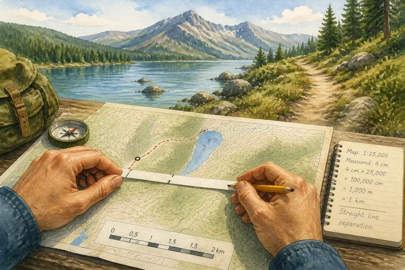
Start by measuring the straight line between the two points on the map. A ruler is convenient, but a strip of paper works too: mark the endpoints on its edge, then compare that marked length with a ruler. For a winding route, transfer the route in sections rather than stretching a straight measurement over each bend.
Next, multiply the map distance by the scale’s denominator, keeping the units consistent. At a scale of 1:25,000, for instance, a measured map distance of one centimeter corresponds to 25,000 centimeters on the ground. Convert that result into meters or kilometers before interpreting it.
Say you are planning a walk between a trailhead and a picnic area on a map marked 1:25,000, and the direct line measures four centimeters. The ratio gives a ground distance of 100,000 centimeters, or one kilometer, as the straight-line separation. If the trail bends around a lake, measure the trail itself in sections; the resulting route distance will be longer.
For a less tidy ratio, the method is identical. Keep the multiplication and unit conversion visible on paper. A small arithmetic slip is easier to catch when the original measurement, scale factor, and converted answer sit in separate lines.
How does a scale bar turn a line into distance?
Compare the measured map line with the scale bar. If the line is twice as long as a bar labeled one kilometer, it represents about two kilometers. If it is half as long, it represents about half a kilometer. For a distance that falls between the bar’s marks, estimate the fraction rather than pretending the map offers more precision than it does.
A strip of paper helps with routes that curve. Put one end at the starting point, mark the first bend, pivot the strip to follow the next segment, and continue until you reach the destination. Then lay the accumulated marks alongside the scale bar. This is a way to transfer a line onto the map’s ruler, not a reason to measure each curve with the straight edge of a ruler.
Scale bars have a practical advantage when a map is resized. If a page or image is enlarged or reduced proportionally, the bar changes size along with the map, so the comparison still works. A printed representative fraction, by contrast, describes the original scale and can become misleading after resizing. On a screen, zooming changes the visible size; use a scale bar that updates with the view, if one is provided.
Why does the map’s scale change your estimate?
Large-scale maps show a relatively small area with more local detail. Their scale ratio has a smaller denominator, such as 1:25,000. Small-scale maps cover a much larger area with less detail, often using a larger denominator. The wording sounds backward at first: “large scale” refers to the size of the mapped features relative to the ground, not to how much territory fits on the page.
At a larger scale, a map may show individual paths, narrow roads, or small bends that disappear on a regional map. At a smaller scale, a route can look nearly straight because the map has simplified its shape. Two distances measured on different maps may therefore differ in how much route detail they capture, even when both maps are correctly scaled.
Scale also affects what a distance estimate can tell you about travel. A measured line is usually a straight-line separation, not the distance along roads or trails. A route may detour around a river, follow a switchback, or connect to a road crossing some distance away. Use the mapped route when the question is how far you must travel, and use the direct line only when the question is how far apart the points are.
What questions come up when measuring map distance?
Does a scale bar still work after a map is copied?
It works if the map and its scale bar are resized together. A ratio printed as text may no longer describe the copied image’s size, so compare distances against the bar or check the map’s current scale display.
Can a ruler measure a winding route?
A straight ruler gives the distance between its endpoints, not the length of a curved path. Transfer the route in short sections with a paper strip, then compare the accumulated length with the scale bar.
Why do two maps give different distances?
They may show different route details or simplify bends differently, particularly if their scales differ. Check whether you measured the same path on both maps and whether the displayed map has been resized.
Does ground distance predict walking time?
Distance alone does not account for slope, surface, crossings, or stops. Treat it as one planning clue, then consider the route conditions shown on the map and your own pace.
How precise should a map distance be?
A measurement should not claim more precision than the map can support. The line has thickness, the endpoints may be approximate, and a printed map may have been resized. Reporting a route as roughly two kilometers is more honest than presenting a string of decimal places derived from a ruler mark that was never that exact.
For any estimate, identify what you measured: the direct separation or the route. Then state the scale method and round the result to a sensible level. When the map’s scale bar and representative fraction are both visible, they should tell the same basic story; if they do not, check for resizing, unit confusion, or a measurement taken from the wrong line.
That distinction is the useful habit: scale converts a map measurement into ground distance, while route shape determines what distance the journey actually asks you to travel. Keep both in view, and a map’s tidy line becomes a more honest estimate of the ground ahead.